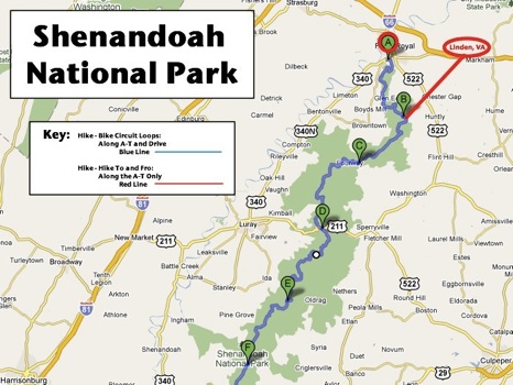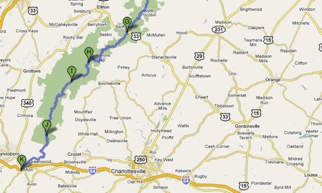
My hike was 125 miles: 115 miles along the Appalachian Trail plus another 10 along Shenandoah’s Dickey Ridge Trail to the park’s entrance. In addition, I biked 105 miles along Skyline Drive. I have no idea where I got the idea pursue this big goal but I can briefly describe how I did it.
Stage 1: It all started innocently enough. “Why not hike a little section of that famous Appalachian Trail which runs 2,170 miles from Georgia to Maine?” I thought. Linden, VA on Interstate 66 was a convenient place to start so I did a couple of one-day hikes along it till I reached Skyline Drive which runs along the ridges of the Shenandoah National Park. When I arrived, the next phase of my adventure occurred to me.
 Stage 2: “Since the Appalachian Trail runs roughly in parallel to the Skyline Drive why don’t I continue with day hikes but plan to return to my starting point each day by bicycle?” This way I figured I could make much better progress.
Rather than hike only 5 to 8 miles each day and have to retrace my steps as I had so far, I could instead hike 10 – 13 miles and return by bicycle. Logistics were a bit more involved since I had to drop off my bike at the start of each day before I could begin my hike. Still, I could usually leave home by 7:30 and be hiking by 10:30 get to my bike by 3:30 and be back to my car and on the road home by 4:30. I always hoped to be home by 6:00 PM.
This approach worked well. With each circuit hike I was making substantial progress: 11 – 13 miles per day. At this pace I figured I could hike the entire length of Shenandoah A-T in about 10 hikes. That’s when the big goal was born. That’s when I got serious.
The routine set in and I made regular treks to Shenandoah National Park. The hiking was gratifying. The biking was both exhilarating (gliding downhill) and excruciating (fighting uphill). However, after a while, as I got further and further from D.C. I started to leave home earlier and get home later. I needed to adjust my approach.
Stage 3: I was getting too far from home to maintain my pace but I still had four hikes left to reach the South Entrance of the park. “Four hikes. Divided by two is two. Why don’t I shift to two-day hikes and spend the night near by?” And that’s what I did.
The park is broken into three Districts which are defined by two roads that cut through the park. Dividing the North from the Central district is US 211 passing through Panorama. Between the Central and South Districts is US 33 at Swift Run Gap. I would use my two-day hike strategy in the South District. First outing I camped at Loft Mountain; second outing was a Days Inn night.
This approach worked well for a couple of reasons. One, I’d be so tired after the first day that I’d sleep like a log, rise early and attack the next day with an early start. Two, I staged the hikes so my second hike was several miles shorter and I’d have the strength to finish. Hey, I know my weaknesses! Besides, there were rewards to this approach and they were 1) getting home early to my family and 2) being able to take a shower!
Stage 4: As great as it was to emerge out the South Entrance I had a slightly hollow feeling inside. “I didn’t really walk the length of Shenandoah National Park because the Appalachian-Trail doesn’t connect into Skyline Drive until Mile 10.2.” I had to remedy this. I had one more hike to go.
Back to the North Entrance I went! The Dickey Ridge Trail runs along the Skyline Drive until it connects into the Appalachian Trail at Compton Gap. This probably means nothing to you but it gives me a chance to introduce the map below. Dickey Ridge runs from “A” to “B”. Completing that segment meant I’d hiked and biked the entire length of Shenandoah National Park.
Very gratifying to be done. I enjoyed it. Now I wonder, “What next?”
Click on the links in the caption to learn more about segments …


Hike Segments: First Hike: Linden to US522; Entering SNP: US522 to B; First Hike-Bike: Between B & C; To Panorama: Between C & D; Almost Half Way: Between D & E; Two Thirds Done: Between E & F; South District: Between G & K; Dickey Ridge: Between A & B.